This blog aims to provide current conditions in Nepal after the August 26 flash flood and trekking possibilities in major regions like Langtang, Annapurna, and Manaslu. The blog contains sensitive images of the devastating flood of August 2026 in Nepal, originating from the Lhende River, which is a transboundary tributary of the Bhote Koshi River. The incident is still ongoing, with no total confirmed deaths.


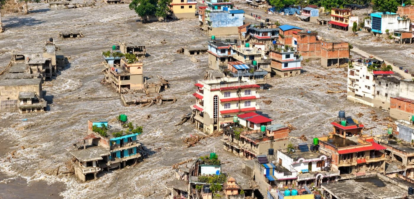
Nepal Flash Flood August 2026 — Langtang, Annapurna and Manaslu Trek Status Update

What happened on 26 August 2026 in Nepal?
On 26 August 2026, around 9 to 10 in the morning, news spread widely about a flood in the Timure village of Rasuwa District; the public statement claimed that the whole village was engulfed by the flood. The news spread widely, and footage of the flood began surging on social media, showing devastating floodwaters flowing downstream through the marketplace, highways, and towns from Rasuwagadhi to Trisuli Bazar. Multiple lives were lost; as of August 27, at least 95 deaths were confirmed in Nepal and 3 in China, with the total regional death toll along the border reaching 165. Hundreds remain missing, including 384 tourists, 291 of whom are foreign nationals from countries including Australia, the United States, Britain, Malaysia, and South Korea. Rescue operations are ongoing, and figures are expected to rise.
What was the cause of the flash flood?
According to USGS, Planet Labs' analysis has identified an ice-rock landslide roughly 20 km northeast of Rasuwagadhi, which triggered a debris-laden flood entering the Lhende Khola. The USGS initially interpreted the seismic signal as an earthquake but later determined that the signal was associated with the glacial collapse itself, rather than an earthquake triggering the event. - USGS
With the following event, the landslide mixed with the Lhende Khola, bringing a muddy flood to Griyong port and entering Nepal’s river system (Bhotekoshi and Trisuli).
Scale of flood on the Nepal side of the border
The flood initially hit the Giyrong port of China and the Rasuwagadhi post; by 10:00, the flood flowed downstream to Trisuli Bazar into the Trisuli River and continued downstream along the Trisuli River, hitting major areas like Dhading, Nuwakot, and Chitwan. Major towns and bridges connecting districts were swept by the flood, which resulted in a complete temporary shutdown of the Prithivi Highway. Quick actions and rescue efforts are ongoing to open highways and rescue flood victims in the affected region.
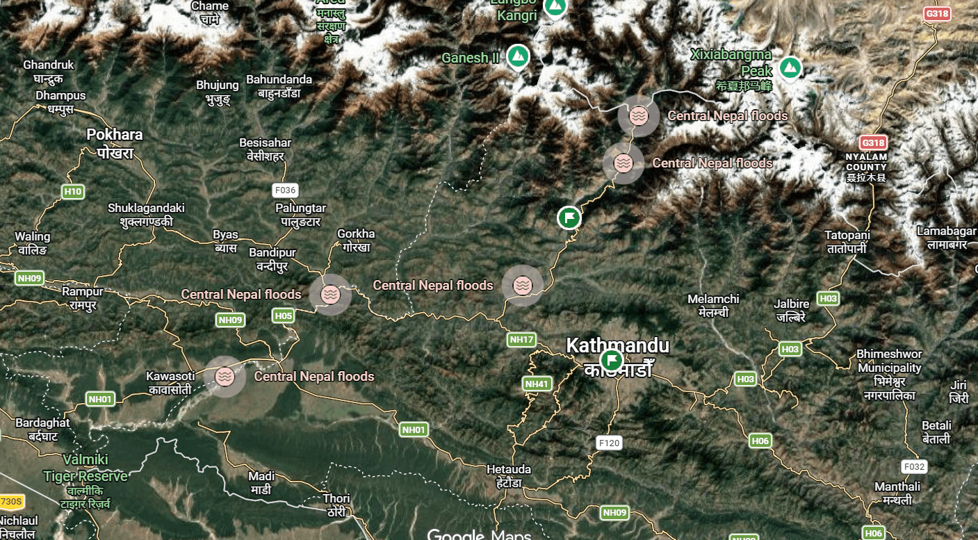
Photo: Satellite image of the flood scale.
What is the impact of the August flash flood in the major trekking region of Langtang, Annapurna, and Manaslu?
As you all might know, September to November and early December is the major trekking season in Nepal. With more stable weather conditions and clear days, trekking has been a popular adventure activity that is mainly centered around the Langtang, Annapurna, and Manaslu regions. But with such a devastating disaster that engulfed major parts of Nepal, is it possible to trek in this region?
The honest answer is that there is no certainty for all the regions, especially the Langtang region.
Langtang and Gosaikunda Trekking
The gate to Langtang village is Syafrubesi itself. From the northeast of Kathmandu, Syafrubesi is the checkpoint and gateway to Langtang Valley; it is also a small port for trade trucks from the border of Tibet. The Pashang Lhamu Highway, which connects Trishuli town and other places like Dunche and Syafrubesi, which are major towns of Langtang and Gosaikunda, is heavily impacted by the flood. Although Dunche town itself is at a higher altitude, the highways leading to it from Trishuli town are currently on high alert due to the flood. As for Langtang trekking, which was done through the Syabrubesi, it is uncertain when this route will open since the lower town, including the highways, bridges, and checkposts, was completely swept away by the flood.
The Manaslu Circuit Trek and the flash flood.
The Manaslu Circuit Trek, which is typically accessed through the Malekhu-Dhading bridge in recent years, at the moment there is no public transportation access, as the connecting concrete bridge itself was swept away by the flood on 26 August, 2026. But it can be accessed through the Beni Ghat – Sundar Bazaar (Old Dhaing) and then down to Dhadingbesi – Arughat – Machha Khola. This option requires hiring a private jeep, as the drive is on an unpaved road. Another best alternative route is the Kathmandu–Barpak–Larpak villages route, which was once the main access to Manaslu before the Kathmandu–Dhading–Arughat road.
How are the famous Annapurna Circuit and other treks around after the monster mud flood?
The Annapurna region is in an uncertain position at the moment. For trekking to the Annapurna region, there have always been two ways: taking the highway or taking a flight from Kathmandu to Pokhara, which is the gateway to Annapurna. So, doing short treks like Annapurna Base Camp, Mardi Himal, and other treks in the region is possible through the flight, although it can be costlier but is the safest option. But what about the Annapurna Circuit Trek?
Although flying is possible to the Annapurna region, the Annapurna Circuit route is a bit different. The circuit trek circles from the border of the Manaslu region and later heads to the upper part of the Annapurna Region from Dumre and Jagat. Although roundabout ways, like taking a flight to Pokhara and taking a private jeep back to Dumre, are possible, they are more costly and not recommended currently. Why? The Prithivi Highway is not only for travelling to tourist places but is also a major connecting highway used for trading as well, so it can’t stay closed for a long period, since it can strain the economy itself. As debris on the Prithivi Highway is being cleared, it is set to open by noon on Thursday. So, the Annapurna Circuit Trek is possible in the coming days but not immediately.
What about other regions like Ganesh Himal and Helambu?
Unlike Annapurna and Manaslu, the Ganesh Himal trekking region, or the remote trekking region of Ruby Valley, was accessed through two major sides from Dhading and Rasuwa. Since the connecting bridge from Dhading to Malekhu was completely swept away, it is nearly impossible to reach it from Dhading until a temporary bridge is built, which can take time. From the Rasuwa side, the route was mainly through the Syafrubesi and Galtang villages, but since the flood itself originated from the Rasuwa border side and caused heavy damage in Syafrubesi, it is also nearly impossible until further notice. So, trekking Ruby Valley is not possible for the moment.
As for Helambu, which also connects to Gosaikunda and Langtang Valley, it is safe since Helambu uses a trail from a different side of the flood zone, but the trail can only be back and forth, unlike the traditional round trail, which ended at Syafrubesi and Dunche.
What can you do currently?
If you have a booking in any of the mentioned regions, you can check with the Nepal Tourism Board or constantly check trusted news sources about the current conditions. Get official updates from:
→ Nepal Tourism Board: ntb.gov.np
→ NDRRMA Nepal: ndrrma.gov.np
→ Nepal Police emergency: 100
→ Tourist Police: 01-4247041
Embassy emergency contacts for affected nationalities:
→ Australian Embassy Kathmandu:
+977-1-4371678
→ UK Embassy Nepal:
+977 1-4237100
→ US Embassy Nepal:
+977-1-4234000
→ Indian Embassy Nepal:
+977 9810326117 (All active on WhatsApp)
If you’re looking for alternative routes, you can contact us and inquire about the trails and accessibility; we will help you within our reach.
Seasonal trekking update in the Annapurna, Langtang, Ganesh, and Manaslu regions?
The flash flood from the northeast of Kathmandu, in the Rasuwa District, caused major damage along the river systems. Where multiple highways, towns, and bridges collapsed, disrupting traffic flow. Recently, the aftereffects of the flood damaged a highway base near Muglin, the Prithivi Highway connecting Kathmandu and Pokhara, which is temporarily closed until further notice.
As you all know, Pokhara is a major stop and tourist destination for trekking to the Annapurna region, including the upper parts, and the highway also led to other important trekking starting points in Manaslu. Since the flood in the Trisuli River damaged most bridges and highways, many trekkers completely believe trekking is not possible this September season, but is it true?
Yes, a few trekking regions were completely isolated due to damage to infrastructure like bridges, which were crucial for crossing the Trisuli River. Trekking regions like Ganesh Himal and Langtang were completely shut down since the flood originated near the Langtang region and caused major damage in Syafurbesi, which was the starting point, and with recent damage in Krishnabhir, transportation to the Manaslu Trekking Area also seemed impossible.
But with recent updates and government aid in finding alternatives, trekking in this region is possible even in September.
The Annapurna Trekking Region Alternatives
The Annapurna Trekking Region houses multiple trekking routes, itineraries, and destinations, and all of them are accessible from Pokhara, not Kathmandu, except for the circuit trek. Kathmandu is the entry point to Nepal, and Pokhara is the gateway to Annapurna. But since international flights are mainly operated from Kathmandu, most trekking or travel to Pokhara is done from Kathmandu using the highway. But that doesn’t mean Pokhara is accessible only by road. Currently, there are two alternatives to reach Pokhara.
- Flight to Pokhara: Pokhara has its own international airport but has rarely operated international services. But domestic flights are possible most of the time, and they are also the safest alternative to Pokhara. The downside of flying is that costs can change anytime during peak trekking season and festival time in Nepal, starting from late September and in November.
- Alternate connecting highways: Another alternative to reach Pokhara is using detours or connecting highways. The alternate route used right after the disaster was the Narayanghar-Mugling road via Hetauda, which can take more than 10+ hours to reach Pokhara, even more with heavy traffic. Another recently opened alternate is using an intact bridge near Galchi and using underdeveloped roads along the Trisuli River via Dhading and through Gorkha to Manakamana and eventually to Pokhara.
Our sources have assured that the road leading to Dhading from the opposite hills of Trisuli is mostly safe, since most jeeps operating to Dhading are using the same alternate, but note that only 4x4s and two-wheelers can use this alternate.
The Manaslu Region and Ganesh Himal Trekking
Unlike Pokhara, which had multiple routes and transportation options, both the Manaslu and Ganesh Himal Trekking Regions were accessed using only 4-wheelers (jeeps). Although buses do operate to a certain distance, jeeps were the most reliable and fastest option. Because both regions used a section of the Trisuli River, the Malekhu Bridge, which was completely swept away, it was nearly impossible to reach either region. Although Manaslu had an alternate old route from Barpak-Larpak, which took a roundabout from Mugling, the damage in the Krishnabhir closed that option too.
Another alternate is using the same route to reach Pokhara. Ganesh Himal was primarily accessed via Dhadingbesi District, and the alternate route to Pokhara from Galchi-Adamptar reaches Dhadingbesi.
The same route to reach Dhadingbesi was primarily used for reaching Dharapani or Jagat of the Manaslu region from Arughat. So, both Manaslu and Ganesh Himal trekking are possible with a short diversion in the river for an hour or two.
The Langtang-Gosaikunda Alternate
Since the flood originated from Rasuwa District, the gateway to Langtang Valley, the Langtang trek is temporarily halted. With the number of deaths, including trekkers heading to Gosaikunda and Langtang, most travellers feel unsafe and are concerned about the situation, which is totally reasonable.
Although there is no complete construction of new bridges to reach Dunche, Bailey bridges are being laid for temporary crossing, and most traffic is being diverted from Nuwakot, avoiding the flood-affected areas, to reach Dunche, from where Langtang and Gosaikunda trekking is possible and safe.
Is it safe to Trek or Visit Nepal after the Flash flood?
Through our own independent research, we have found that many trekkers are hesitant to visit Nepal after the recent disaster. And it is reasonable to be cautious. With the increasing number of deaths among both locals and foreign travelers, no one can force anyone or misinform them.
The damage from the flood hit major towns and connecting bridges, which were crucial for crossing the hilly river system to reach anywhere in Nepal. The flood from Rasuwa mixed into the Trisuli River System and damaged highways and other significant infrastructure, with heavy loss of life. When such a disaster strikes, it is right to be cautious about visiting the same place, but the difference is that there has been other misinformation being spread, or rather, misunderstood information.
The cause of the flood was a glacial collapse in Nepal side at Langtang Lirung, the report was later given by the USGS. The collapsed glacial hit the Lhende River and brought a landslide-mixed flood to Gyirong Port and entered Nepal. The river later merged into the Bhotekoshi and Trisuli, which stretched through multiple districts, and it led to the misunderstanding that the flood hit every part of Nepal, which made most believe that Nepal is facing a dangerous situation across the whole country.
The most probable cause of unsafe trekking information is the number of deaths of foreigners who were heading to Langtang, Gosaikunda, and Tibet through Nepal.
And since the cause of the flood was an avalanche/glacial collapse, it is natural to be concerned about treks. So, is it truly safe to visit Nepal for trekking?
Foremost, the trekking region is vast in Nepal, stretching from the eastern side to the western side, and the flood hit one region or the route to that region on the Northeast side. But the crucial part is, that one particular section and the towns leading to it were a significant part of the Langtang Valley Trek and Gosaikunda. The damage completely blocked access to these trekking areas, which made it unsafe to travel in any of these areas. The trekking area itself is not in a danger zone, but the route to it was in danger, except Syafrubesi, which was an important hub for Langtang trekkers, and the flood completely swept the base of the valley.
The trails and the trekking valley are safe, but the roads leading to it were damaged and blocked by the flood. But what about Annapurna and Manaslu, which are hundreds of miles away from the flood, yet most agencies had to divert the trekking itinerary?
See, the highways leading to both of these regions go along the Trisuli River, where the flood from Rasuwa merged and hit bridges, riverside towns, and highways, and was given notice to not travel since these river sections were unsafe during the flood, not the trekking area itself. The trekking trails place in lot higher and farther from the flood-affected areas. Although you do have to cross the same river, it is still safe since there are multiple alternatives, and Bailey bridges are also being laid for temporary crossing if it is necessary.
For Annapurna, you can directly fly to Pokhara, completely avoiding traffic and flood areas, and trek safely since Annapurna Region trekking always starts from Pokhara. So, yes, it is safe to visit Nepal, and trekking can be done safely. But the choice is still with you; if you feel concerned, you can always postpone the trek, since the season is still in the beginning phase and has yet to reach peak time.
Seasonal Trekking: New updates and latest news topics:
Short topics and highlights
-
The Prithivi highway remains completely closed to all traffic after the flood completely swept away a section of the foundation in the Krishna-Bhir area.
Alternative used: Light vehicles and microbuses are being rerouted via the Makwanpur Pharping network.
Note: The highway has once again opened; the authorities have cut a section 20 meters above the landslide to open two-way traffic. Do travel cautiously.
- Major parts of the Pashang Lhamu highway remain closed, as more than 40 km of highway and bridges were damaged by the Bhotekoshi flood.
Alternative used: Light vehicles and two-wheelers are being rerouted from Bidur via Saramthali to Zero Kilometre in Nuwakot to reach Dunche. Note: This route is extremely narrow and slippery, and only 4x4 vehicles can pass through.
FAQs
1. What are the current alternatives for reaching Pokhara from Kathmandu?
The Prithivi Highway runs along the Trisuli River system, where the Bhotekoshi flood was mixed in, which tore apart part of the highway in Krishna Bhir. So, the Prithivi Highway near the Mugling-Kathmandu side is temporarily closed, and most light traffic is diverted from a roundabout through Hetauda to Chitwan, Narayangadh, connecting the highway again to Pokhara.
2. What is the safest alternative to reach Pokhara?
Comparatively, the original route is closed, and the alternate route from Chitwan will have high congestion, and another alternative through Palung, Tanahun, can’t be reliable, as these routes are mostly used by locals only, with no definite infrastructure, so the flight option is the safest option. Although air ticket prices are facing constant hikes, it is the surest and safest option from traffic and floods.
3. What is the current flight cost from Kathmandu to Pokhara?
The current flight cost is USD 125 per person, but it can change significantly since the trekking season is still in the beginning phase, and it can change during peak time.
4. Is it possible to do the Langtang Valley Trek from September to early December?
There are three routes to Langtang: the most popular from Syafrubesi, another through Dunche including Gosaikunda, and an underrated trek from Helambu. Currently, Syafrubesi is nearly impossible to operate and can’t be said for another month, since the base of Syafrubesi, including the hydro project side and connecting bridges, including the highway leading there, was completely swept away.
But how about from Dunche? The Bhotekoshi River merges into the Trisuli River system in Betrawati, Bidur, and Trisuli town, and to reach Dunche, you have to first go through this town, but the flood hit these major towns and swept away bridges that were important for crossing to reach Dunche. But it is still possible since the Government of Nepal has redirected light vehicles like microbuses, cars, and two-wheelers to alternate routes via Nuwakot. Although it takes time, you should be able to reach Dunche and trek from there. The Helambu Langtang trek is still safe; it starts from Kathmandu, but you can’t follow the standard plan of ending at Syafrusbei and have to divert to Dunche.
5. What is the prospect of trekking after the flash flood?
The 26th August, 2026, the flash flood hit the major trading route of Tibet-Nepal and the trekking junction (Syafrusbei), halting any possibility of trekking in the Langtang Valley. But rest assured, alternatives are already available to reach the trekking starting point, and agencies are also changing the itinerary to accommodate the safest route to operate trekking in Langtang, Annapurna, and Manaslu. You can also coordinate with Wilderness Excursion to get live updates and alternate routes for every trekking region. In a month, it should be possible to trek safely in any region since alternate routes are already being published by the Government of Nepal as well.


7 reviews
14 Days
Price From
US$999
US$1099
Top-Rated Trekking Experience
Need Help? Call Us+977 9851042153orChat with us on WhatsApp
Latest Travel Blogs

Need Help? Call Us+977 9851042153